Piercing the veil
A new exhibition at Buxton Contemporary finds a rich complexity in the shadowy terrain between life and death.
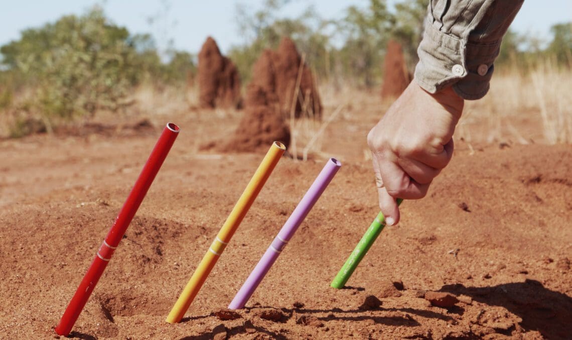
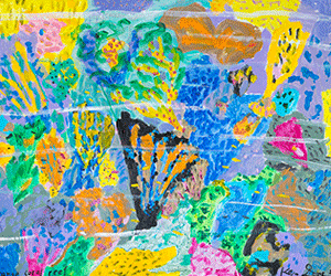
Sonia Leber and David Chesworth, Where Lakes Once Had Water (video still), 2020,
2-channel 4K UHD video, stereo audio, 28:24 minutes. University of Wollongong Art Collection. CABAH Art Series Commission in association with Bundanon. Filmed on the lands and waters of the Mudburra, Marlinja, Jingili, Elliot, Jawoyn and Larrakia communities in Northern Territory, Australia, with additional filming and editing on Barkandji, Dharawal, Djabugay, Yidinji and Wurundjeri Country.
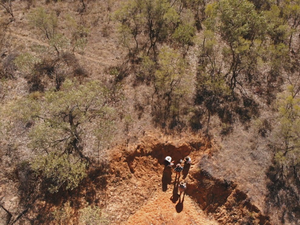
Sonia Leber and David Chesworth, Where Lakes Once Had Water (video still), 2020, 2-channel 4K UHD video, stereo audio, 28:24 minutes. University of Wollongong Art Collection. CABAH Art Series Commission in association with Bundanon. Filmed on the lands and waters of the Mudburra, Marlinja, Jingili, Elliot, Jawoyn and Larrakia communities in Northern Territory, Australia, with additional filming and editing on Barkandji, Dharawal, Djabugay, Yidinji and Wurundjeri Country.
Sonia Leber and David Chesworth, Where Lakes Once Had Water (video still, detail), 2020, 2-channel 4K UHD video, stereo audio, 28:14 minutes. University of Wollongong Art Collection. CABAH Art Series Commission in association with Bundanon. Filmed on the lands and waters of the Mudburra, Marlinja, Jingili, Elliot, Jawoyn and Larrakia communities in Northern Territory, Australia, with additional filming and editing on Barkandji, Dharawal, Djabugay, Yidinji and Wurundjeri Country.
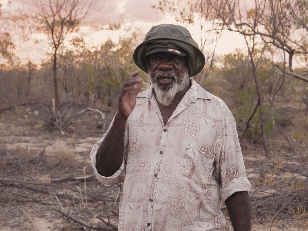
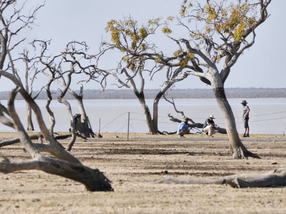
Sonia Leber and David Chesworth, Where Lakes Once Had Water (video still with Ray Dimakarri Dixon near Lake Woods), 2020, 2-channel 4K UHD video, stereo audio, 28:24 minutes. University of Wollongong Art Collection. CABAH Art Series Commission in association with Bundanon. Filmed on the lands and waters of the Mudburra, Marlinja, Jingili, Elliot, Jawoyn and Larrakia communities in Northern Territory, Australia, with additional filming and editing on Barkandji, Dharawal, Djabugay, Yidinji and Wurundjeri Country.
Sonia Leber and David Chesworth, Where Lakes Once Had Water (video still), 2020, 2-channel 4K UHD video, stereo audio, 28:24 minutes. University of Wollongong Art Collection. CABAH Art Series Commission in association with Bundanon. Filmed on the lands and waters of the Mudburra, Marlinja, Jingili, Elliot, Jawoyn and Larrakia communities in Northern Territory, Australia, with additional filming and editing on Barkandji, Dharawal, Djabugay, Yidinji and Wurundjeri Country.
Sonia Leber and David Chesworth, Where Lakes Once Had Water (video still, detail), 2020, 2-channel 4K UHD video, stereo audio, 28:24 minutes. University of Wollongong Art Collection. CABAH Art Series Commission in association with Bundanon. Filmed on the lands and waters of the Mudburra, Marlinja, Jingili, Elliot, Jawoyn and Larrakia communities in Northern Territory, Australia, with additional filming and editing on Barkandji, Dharawal, Djabugay, Yidinji and Wurundjeri Country.
Those who have travelled a few hours inland from the Australian coastline can attest to observing a very different view of the landscape. Rain forests and ocean give way to red dirt and open plains, and a lack of mountains allows the eye to see far into the horizon. While the desert landscape can initially appear desolate, it holds within its soil and sediment a vast history of climate patterns and human interventions.
It is the process of deciphering this history that Naarm/Melbourne-based artists Sonia Leber and David Chesworth depict in their recent video and sound installation, Where Lakes Once Had Water.
Traveling through the Northern Territory with a team of Earth scientists from the Centre of Excellence for Australian Biodiversity and Heritage (CABAH), Leber and Chesworth visited Lake Woods, Nitmiluk/Katherine Gorge and Girraween Lagoon, to observe how information on deep time climate cycles is sourced.
Under the guidance of local Indigenous leaders, the CABAH team (led by Dr Tim Cohen and Dr Cassandra Rowe) collected soil and sediment samples, while the artists filmed and recorded different aspects of this process.
“What was really interesting to us was being on site together,” says Leber. “Here we were—different people from different persuasions—experiencing the same environment yet everyone using separate tools and knowledge to reach into deep time. We were all seeing way beyond the present conditions.”
The video opens at Lake Woods, a seven-hour drive south from Darwin. Leber and Chesworth are filming Marlinja man Ray Dimakarri Dixon as he calls to the spirits of Country. Chesworth recalls the experience as deeply moving.
“Ray had a way into this world. Right from the start of this film you see there’s a human way of interacting with our surroundings that embraces a spiritual engagement. We become aware of his attentiveness to nuances and changes in the environment.” From here, the video takes in multiple views—from microscopic samples in the laboratory to expansive aerial views of ancient shorelines and riverbeds.
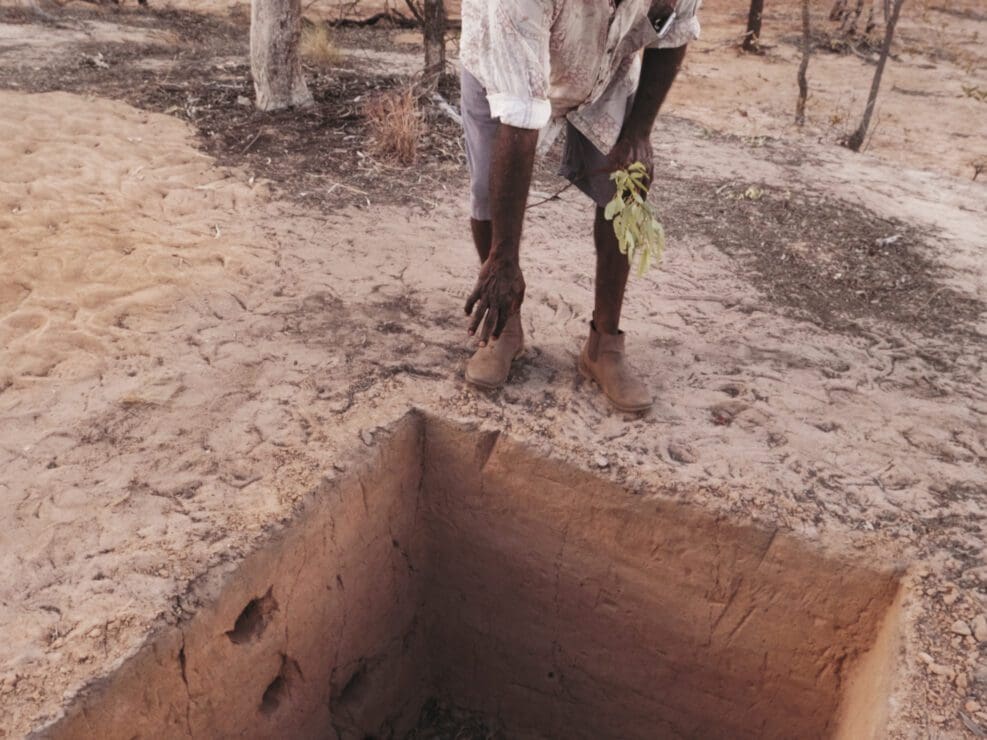
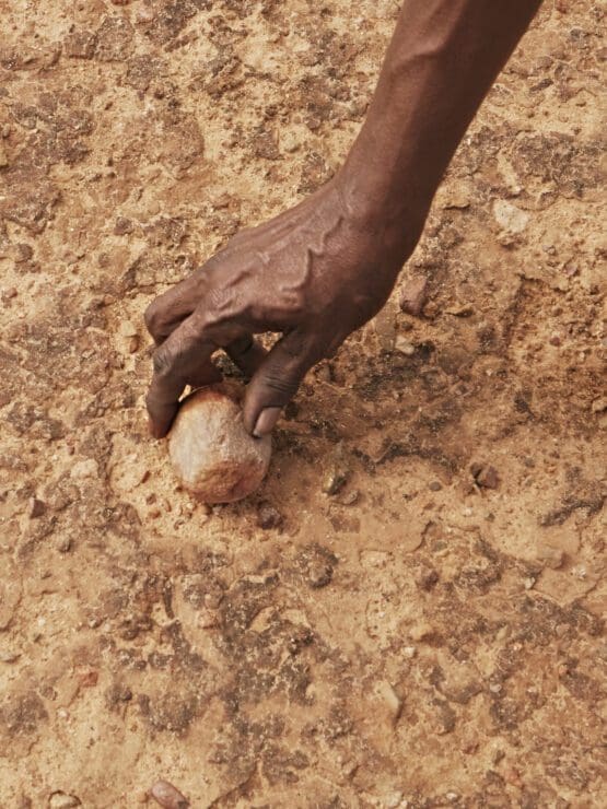
Working in both wet and dry locations, the CABAH team begin their search for information by digging into the earth with a shovel or pushing an auger (a spiral shaped tool designed to drill holes into the ground and siphon out materials) into sediment. In his catalogue essay, Professor Tim Flannery likens the layered sediments found in lakes and lagoons to “a gigantic, environmental tape recorder”.
Each extraction method revealed a wealth of material going back hundreds of thousands of years. “Testing can show if charcoal in the sediment came from a human made fire, or a natural bushfire,” says Chesworth. “They can see when the land was occupied by people for the first time and the environmental changes caused by colonial occupation.” Hydration levels, vegetation patterns and variations in temperature can also be tracked.
To visually express the numerous ways of engaging with the landscape the artists witnessed, Where Lakes Once Had Water consists of two large screens, each combining different yet inherently connected views. Leber explains how this works. “An example of this underlying connection comes when we see a heron wading very slowly through the water of a lagoon. It cranes its neck and dips its head down to observe something in the water. On the opposite screen, a scientist peers into a microscope. Shown side by side, we see both are investigating, intent on learning more about their environment.”
In addition to the visuals, Where Lakes Once Had Water contains a multi-layered soundscape. “The environment was quite silent in many places,” reveals Chesworth. “Without layering in music or putting in sounds that weren’t actually there, we decided to tune into what’s known as the electromagnetic spectrum, which is basically the radio waves that surround us all the time.”
Emanating from the surrounding environment, and the machines and scientific instruments being used on the field, the soundtrack also includes bird song from red-tail black cockatoos, human voices and trickling water. At varied points the sound of a microphone tracing the contours of an excavated pit is heard, which Chesworth says, “draws attention to the sensorial interface we have with the environment. All the sounds come from a way of sensing the environment.”
A key researcher on the project was Dr Michael-Shawn Fletcher, a Wiradjuri scientist who joined Leber and Chesworth at the Girraween Lagoon site. For Leber, it’s scientists like Fletcher who embody the future of work in the field by fostering a collaborative view to science, bringing together multiple viewpoints to gain a wider perspective of nature and climate change.
“It’s the cultural knowledge of plants and animals and ways of managing the land which we’re slowly becoming more aware of,” Leber says. “That cultural knowledge is really going to open up the science.”
As Chesworth concludes, “Where Lakes Once Had Water reflects a growing interest in other ways of considering the world. Hopefully it will trigger audiences to ask questions and think a little differently about the Australian landscape.”
Where Lakes Once Had Water
Sonia Leber and David Chesworth
Charles Darwin University Art Gallery
20 April—15 July
A new exhibition at Buxton Contemporary finds a rich complexity in the shadowy terrain between life and death.
In Cézanne to Giacometti: Highlights from Museum Berggruen / Neue Nationalgalerie currently showing at the National Gallery of Australia, viewers are invited to share a journey through the history of modern art from across the globe.
In our ongoing series, Shelf Portraits, Art Guide writers recommend the books—recently published or deserving of more attention—that shed new light on an idea that has long simmered in the art world or has helped them see a familiar medium in a different light.
Blak In-Justice, now showing at Heide Museum of Modern Art, challenges the brutal systems that shape Indigenous incarceration in Australia—while charting the healing power of ancestral knowledge in the process.
At once an exhibition, performance series, and community-led workshops, Push / Pull is an ambitious program that brings together themes and areas of focus that honour the histories of Adelaide Contemporary Experimental as a platform for radical experimentation.
In our ongoing series, Shelf Portraits, Art Guide writers recommend the books—recently published or deserving of more attention—that shed new light on an idea that has long simmered in the art world or has helped them see a familiar medium in a different light.